City Heights
OH! San Diego 2022 Tour

About City Heights
City Heights often gets overshadowed by its trendier neighbors North Park, Kensington and Hillcrest. However, hidden within is one of San Diego’s most diverse and culturally rich communities. Home to a refugee population with Southeast Asian and African roots, City Heights has embraced immigrants as its own, and they have reciprocated in kind.
One glimpse of the central San Diego neighborhood and you can feel its diversity. After the Vietnam War, refugees from Southeast Asia arrived at Camp Pendleton in San Diego County. Many of them, drawn by its low rents, settled in City Heights. It launched an influx of immigration that continued into the 1980s and 1990s, when resettlement agencies directed refugees from the Somali Civil War to City Heights. An example of the community recognizing and celebrating this diversity is the six-block area known as Little Saigon.
While City Heights residents have been known to struggle with poverty, the neighborhood has undergone a metamorphosis in recent years. Change first got underway in the 1990s when philanthropist Sol Price led and financed a redevelopment plan to create an Urban Village. Today, the neighborhood, flanked by University Avenue, El Cajon Boulevard, Fairmount Avenue, and Euclid Avenue, springs to life. Highlights like the Ocean Discovery Institute, the City Heights Skatepark, and The Avenue Mural Project have helped propel the resurgence — one that shows no sign of slowing down.
City Heights’ vibrancy is on full display through the many public art murals you’ll encounter along the way – the work of the Avenue Mural Project.
Mid-City Skate Park/Park de la Cruz - click for info
Address: 3901 Landis Street Architect: Schmidt Design Group Completed: 2017
Mid-City Skate Park stands as proof of how a group of dedicated youth can make a difference in their community. The Mid-City CAN Youth Council put out videos, reached out to residents with skate demos, and toured park sites with local decision-makers. They produced a report demonstrating the safety of skateboarding as compared to contact sports, lobbied elected officials, reached out to skeptical neighbors, and even helped with the design. The park received full funding through a state grant, and their efforts won them an award for Best Grassroots Initiative from the San Diego Chapter of the American Planning Association.


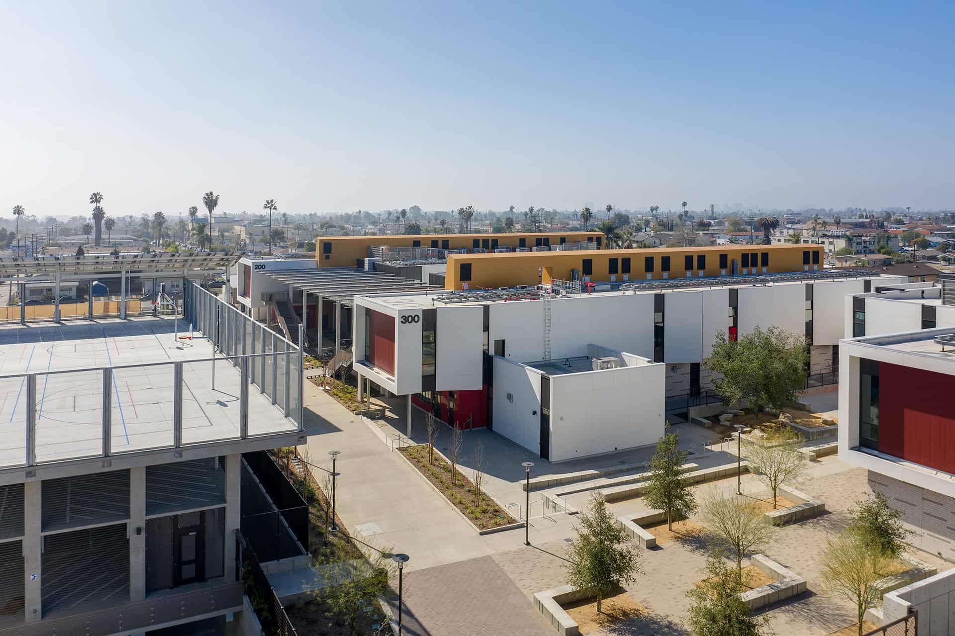
Wilson Middle School - click for info
Address: 3838 Orange Avenue Architect: Roesling Nakamura Terada Architects Completed: 2021
Wilson Middle School is the first phase of a unified Wilson Middle/Central Elementary K-8 campus. This new campus arranges the architecture of both schools around a variety of outdoor active social areas and large open green spaces. The new Middle School consists of (38-53) classrooms and (6-9) science labs, with an Arts center and a community shared Performing Arts Center.
The Middle School is distinguished architecturally from the Elementary School through the use of materials, colors and larger building volumes. Inside, large collaborative spaces replace hallways, and large format video walls greet students and teachers as they arrive. Large vertical windows provide ample natural light into the classrooms. Windows are oriented to capture prevailing air flow while avoiding direct heat exposure. An automated natural ventilation system utilizes fresh outside air when conditions permit to cool the building, while hot air is exhausted through large vertical thermal chimneys.
On the east side of the property, construction has begun on the new Central Elementary School. This school will consist of (40) classrooms, a Health Clinic, and an underground parking structure.


Hoover High School - click for info
Address: 4474 El Cajon Blvd Architect: AVRP Completed: 2021
This new state-of-the-art 500 seat theater and new 3-story multi-purpose building fronting El Cajon Boulevard in City Heights pays homage to the original buildings from the 1930s. These two new buildings replace the existing undersized theater (a portion of the original concrete structure), an administration building and counseling building built in the 1970s, 20 modular classrooms and a modular restroom building. Site work included the reconfiguration of the site fronting the “Boulevard” for improved site access as well as a new academic courtyard.


Little Saigon District - click for info
Address: El Cajon Blvd between Euclid and Highland Avenues Architect: n/a Completed: n/a
Beginning in the 1970’s, Vietnamese businesses began to populate storefronts along El Cajon Boulevard clustering in the six-block stretch between Highland Avenue and Euclid Avenue. Today, a majority of the businesses within the boundaries of the Little Saigon District are owned and operated by Vietnamese-Americans.
For the newly arrived, Little Saigon provides a cultural buffer zone, a cultural bridge, helping to minimize the stress of transition and culture shock. Little Saigon has become not only the commercial hub but the emotional focal point of the Vietnamese community, offering a sense of acceptance, belonging and social ties.
The City of San Diego’s 2013 designation of the area as the “Little Saigon Cultural and Commercial District” validates the incredible amount of perseverance, hard work, and dedication the residents of the district have shown over the past 30 years.
Hungry? Check out the Little Saigon Food Tour map here.


Egyptian Garage - click for info
Address: 4749 University Ave. Architect: Unknown Completed: 1923
In 1922, the discovery of King Tutankhamen’s 3,000 year old tomb in Egypt captured the imagination of the American and European public resulting in an architectural expression known as Egyptian Revival. The movement reached City Heights in 1923 when this building was constructed at the end of the old East San Diego Trolley line. From 1925 to 1932, the building was remodeled and operated as the Egyptian Garage.
Today, the building is home to Big City Liquor and other small businesses while its architectural features, such as pilasters topped with Pharaoh heads, lead glass designs of lotus blossoms and a semi-obelisk rising featuring the Egyptian god Thoth, the ibis-headed moon god, remain intact.


Euclid Tower - click for info
Address: 4757 University Avenue Architect: unknown Completed: 1932/2009
The 80-foot tall Euclid Tower, a City Heights icon, has stood on the corner of University and Euclid for almost seven decades. An example of the Zigzag Moderne Art Deco style, the Euclid Tower was designed by an unknown architect. The original spire sat above a soda/hamburger drive-in and featured an observation deck on the second floor.
By 1999, the tower had deteriorated structurally, and the tall spire of the building was removed. In 2009, a somewhat shorter spire was constructed and the building was restored using a design proposed by Cynthia Bechtel, Mark Messenger and Christina Montuouri. The Euclid Tower now sits over the Tower Bar and Tower Tattoo Parlor. (source: coolsandiegosights.com)


Silverado Ballroom - click for info
Address: 4756 University Avenue Architect: Earl W. Hartung Completed: 1932
The Silverado Ballroom, along with the Euclid Tower and the Egyptian Garage, is one of City Height’s art deco treasures. (The University Avenue facade actually features two architectural styles, art deco to the west of the entry tower and streamline moderne to the east). The two-story, 11,500 square foot Silverado Ballroom reopened in 2016 after receiving a $1.6 million dollar makeover which earned a People in Preservation award from Save our Heritage Organization (SOHO).
The building was painted in period-appropriate white, with period trim in yellow and red. One unseen feature of the original and refinished maple dance floor was retained – two subfloors with build-in shock absorbers to cushion those dancing feet. The ballroom, available for weddings, dances and other community events, is on the second floor, with a restaurant and businesses on the ground floor. (source: Union Tribune, Feb. 17, 2016)


Ocean Discovery Institute - click for info
Address: 4255 Thorn Street Architect: Rob Wellington Quigley Architects; Spurlock Landscape Architects Completed: 2018
Ocean Discovery Institute Living Lab is located at the gateway of Manzanita Canyon and is a joint-use project with the San Diego Unified School District. The Living Lab provides science education to students from 13 public schools in the Hoover High School cluster, creating a focal point for ocean and canyon science education and exploration, scientific research, and environmental appreciation and stewardship.
Every aspect of the 8,000 SF Living Lab is used to facilitate learning about science and conservation, with the theme “if I understand how the world works, I can make a difference”. The facility includes both indoor and outdoor labs, interactive learning opportunities and 35,000 SF of open space. The Living Lab is environmentally sustainable and seamlessly integrated with the natural and cultural environment.


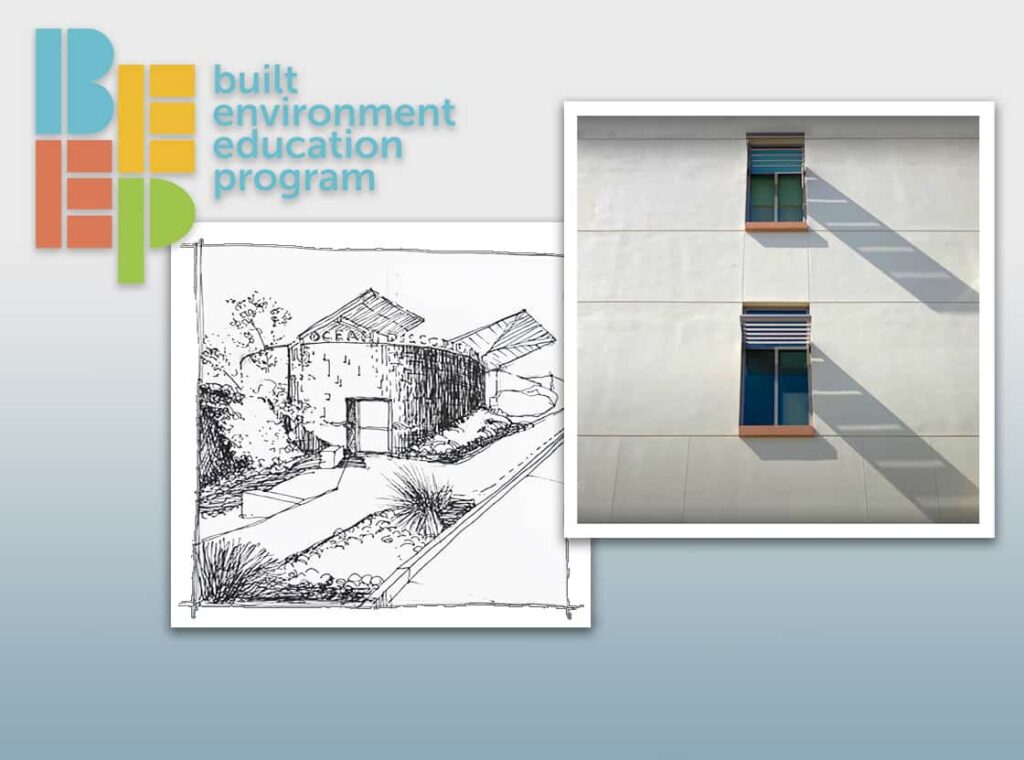
Try your hand at sketching the Ocean Discovery Institute.
View the BEEP KidSketch video tutorial here.
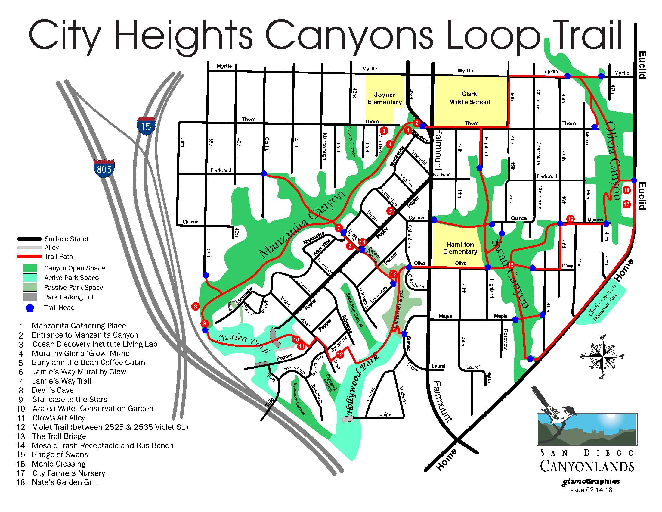
City Heights Canyons Loop Trail - click for info
Address: 32°44'24.9"N 117°06'08.9"W Architect: n/a Completed: n/a
The City Heights Canyons Loop Trail is a 5-mile loop linking four urban canyons: Manzanita, Hollywood, Swan and Olivia. The Canyons Loop Trail serves as a linear park for neighborhood residents and youth with better walking and biking routes to school, as a nature classroom, as well as a hiking and jogging route.
Connecting intersecting dirt canyon trails with paved city streets and sidewalks, the trail is an example of how urban developments can coalesce with the natural environment. The project is the result of collaborative effort between community leaders and volunteers, San Diego Canyonlands, and the City of San Diego. Along the trails you will see on-going restoration efforts in process, removing non-native vegetation and replanting with native species. Winner of 2018 Orchid Award.
View the City Heights Canyons Loop Trail map here
Note: The Manzanita Canyon Trail connects Ocean Discovery Institute with Azalea Park, essentially running parallel to the Pop Art Walk. Enter the Manzanita Canyon Trail from the trailhead adjacent to the Ocean Discovery Institute, accessible from the sidewalk on Thorn Street. Exit at the stairs to Azalea Park, you will be at the northwest portion of the park. Street parking at Manzanita Street/Manzanita Place, or park at Azalea Park and enter the trail from the stairs.


Azalea Park and Poplar Street Art Walk - click for info
Address: Poplar Street & Violet Street Architect: n/a Completed: 2010
Azalea Park Water Conservation Garden
Start at the Water Conservation Garden (the highest point in the park). Go to the automotive panel totem in the far corner, then exit the park into the alley leading away from the park (towards Pepper Drive). Peruse the murals, the turn around and walk back through the park and make a right on Poplar Street. This street, lined with 100 street trees planted by volunteers in the 90s, is lined with public art including murals, mosaic benches and trash cans. The mosaics were installed by a team of volunteers led by local artist Vicki Leon. Look closely to see themes emerging, such as references to the canyons and canyon life surrounding Azalea Park.
Artist Vicki Leon’s studio and Mosaic Workshop is located at 4125 Poplar Street. A team of local mosaic artists is currently at work on 24, Four Elements mosaics that will be installed at Ocean Discovery Institute rooftop planters.
At the intersection of Poplar and Fairmount is the Azalea Park identification sign. Entitled “Art’s Popping Up,” the sign is comprised of intricate mosaics assembled by a team of community volunteers meeting weekly for two years. Each floating frame contains art made by individual community members. At night, the sign lights up with the reflective glow of green LED lights, welcoming its residents home. Learn more about the creation and meaning of the sign here.
From Poplar Street, walk down Glenfield Street to Manzanita Place. At the end of this street is the Manzanita Gathering Place. Overlooking the Ocean Discovery Institute and the entrance to Manzanita Canyon, this quiet respite features a series of mosaic sculptures.


Wat Savannkiri Buddhist Temple - click for info
Address: 3864 52nd Street Architect: n/a Completed: 1982
The beautiful colors, shapes and rooflines of the temple are visible from the surrounding neighborhood and from University Avenue. It is believed that surrounding the temples with protection such as angels, guardians, warriors, lions, and dragons keeps away the evil. The temple buzzes on weekends with a small adjacent market selling produce and treats like Noum Kong (Cambodian donuts). Visitors intimately celebrate special occasions while monks and others prepare light meals within the temple.


Thank you to our City Heights sponsors
Back for a second year as City Heights Neighborhood Sponsor, Citythinkers is an integrated and multi-disciplinary planning, urban design and research-based firm whose central mission is to build a better city. With thoughtful care and attention, we devote our energy, talents and passion toward achieving a quality built environment for people and believe (above all) in making great places. We do this through research, by engaging with the communities around us, and with a passion for design that serves a public good. Based in San Diego, California and with 20 years of experience in the fields of planning and design, the firm’s work ranges in scale and scope from General Plans, to Community Plans, Master Plans, Zoning Codes, Streetscape Design, Design Guidelines and Community Outreach. Our research and design expertise in urban, infill housing and mixed-use informs the planning practice and enriches each planning project with “real world true-testing” of bold ideas and visionary thinking. Citythinkers is currently at work on two projects that will bring much-needed housing to City Heights. Read more here.

")